キーワード:地理空間情報科学、都市工学 空間解析、時空間データ、空間統計学
 ビッグデータの活用が社会のあらゆる分野で本格化し、地理情報も大量化・高度化しています。地理情報ビッグデータの集約と活用方法の開発、数理モデリング技法によって空間意思決定方法へ応用する研究を統合的に追求し、都市計画の政策に反映させることを目的としている空間情報の社会的活用・リサーチユニットは、地理・工学・環境などの他、芸術や人文、医学等の領域の研究者とも連携しながら、都市計画を包含する研究に挑戦しています。
地理情報データを活用し、効率的な街づくりの施策に繋げる
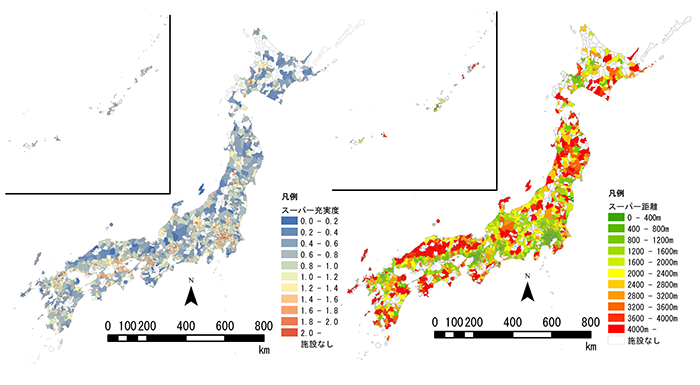
図1:全国にあるスーパーの充実度と平均距離
地理情報データとオープンデータの併用で、効率的な社会の仕組みを提示できます。たとえば、スーパーや保育園、銀行、郵便局などの施設に関する地理情報データと国勢調査の人口データを組み合わせることで、人口・面積に対する施設の充実度と、その施設までの平均距離が算出できます。配置すべき施設の種類や立地についての提言が可能になります。都市計画にはこうした立地の違いを踏まえることが重要だと考えています。
また、坂道の地理データと人口密度のデータを掛け合わせると、電動自転車の使用でメリットを享受できる人が多いエリアを特定できます。これで、レンタサイクルの設置がよいか、個人の購入を促すかといった施策まで導き出すことができます。
道路網データや電柱の分布図を使用して災害時のリスクを低減する
道路網データなどの地理情報は、災害時を想定した都市計画の提言にも活用できます。1999年からの約10年間で行われた平成の大合併によって1自治体あたりの管轄範囲が広域にわたるようになりました。一方で、公共施設は合理化のために統廃合が進みました。その結果、居住者にとっては最寄りの消防署や学校・避難場所が隣の自治体にあるケースが目立つようになりました。道路と行政界の関係を明確にして、自治体の管轄範囲の制約を撤廃した場合にどうなるかを分析することは、自治体の垣根を超えた連携促進に役立つと思います。
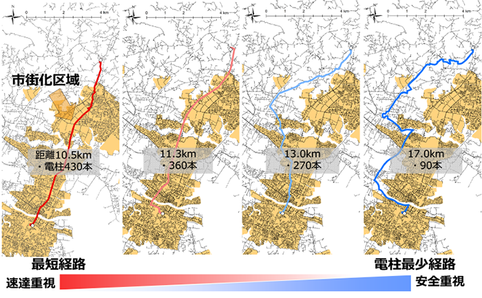
図2:電柱最少経路の検出(青いルートほど安全重視の電柱最少経路になる)
電柱の分布図と、建物、人口データの分析から、無電柱化区域の候補地を特定できます。電柱が密集している市街化区域と市街化する前の調整区域の境目が、最も良い避難経路であることが明らかになりました。また災害により電柱が倒れて道が塞がり、避難場所に行けなくなるような道は、電柱を地中化する、あるいは別の道を提示しなくてはなりません。ここでは避難場所までの最短ルートが機能しなくなった場合の避難経路として「電柱最少経路」を導き出しました。このように、地理情報データは、地震や水害などの大規模な災害のリスク軽減にも役立てられています。
私たちのユニットでは、他にもビッグデータを使い、公共交通の運賃の研究や、快適なランニングコースを造るなどメンバー独自の研究をしています。こうして集まった様々な分析結果は、専門家によって政策決定や企業戦略に活かされるなど、社会実装のための基礎資料として重要なものと考えています。
社会への貢献・実績
- 犯罪・災害などのリスクに対する安全研究
- 安全・効率的で環境負荷の少ない交通体系の研究
- 老朽化する都市基盤施設の維持更新
- 集約型のコンパクト・アンド・ネットワーク型の都市計画の研究
- 空間データを応用した意思決定の社会実装方法や社会的な仕組みの提示
取材日:2020年2月14日
Utilizing Geospatial Big Data to Make Policy Recommendations for Livable Urban Planning
Unit members : Watanabe, Shun Amemiya, Mamoru
Other agencies : Ishii, Norimitsu Watanabe, Daisuke Miyagawa, Masashi Murakami, Daisuke
Unit name: Applied Geospatial Information Sciences
Key words: geospatial information sciences, urban engineering, spatial analysis, spatio-temporal data, spatial statistics
Big data are now utilized in every field of society, and geographic information is getting more extensive and sophisticated. Aiming to make policy recommendations for urban planning, we conduct comprehensive studies for big data application to space-related decision-making, by collecting geospatial data, developing methods for their utilization, and using mathematical modeling techniques. The Research Unit on Applied Geospatial Information Sciences conducts integrated research for urban planning through collaboration with researchers specializing in geography, engineering, and environments, as well as those from other areas, such as art, humanities, and medicine.
Utilizing geospatial data for efficient urban development
Figure 1: Accessibility and mean distances of supermarkets throughout Japan
Combining geospatial and open data, we can propose efficient social systems. For example, a combination of geospatial data regarding specific facilities, such as supermarkets, nursery schools, banks, and post offices, and population data from national censuses allows us to calculate the accessibility and mean distances to these facilities per population and area. In this way, we can recommend the types and locations of facilities that should be distributed in each area. We place importance on taking such differences in location into account when planning urban projects.
Combining geospatial data regarding slopes and the population density, we can also identify areas where many people can probably benefit from electric bicycles. Thus we can advise on where to distribute rental bicycle services or to encourage residents to purchase bicycles for themselves.
Using road network data and utility poles maps to reduce disaster-related risks
Geographic information, such as road network data, can also be utilized to make proposals for urban planning on disaster management. The 10-year municipal reorganization from 1999 increased the jurisdictional area per municipality, thus made many public facilities integrated and abolished. As a result, for an increasing number of residents, the nearest facilities, including fire stations, schools, and disaster shelters, are in the neighboring municipalities rather than the ones they live. Under these circumstances, clarifying the relationships between roads and administrative areas, and analyzing the effects of removing the restrictions of the municipality jurisdiction may help promote collaboration beyond municipal boundaries.
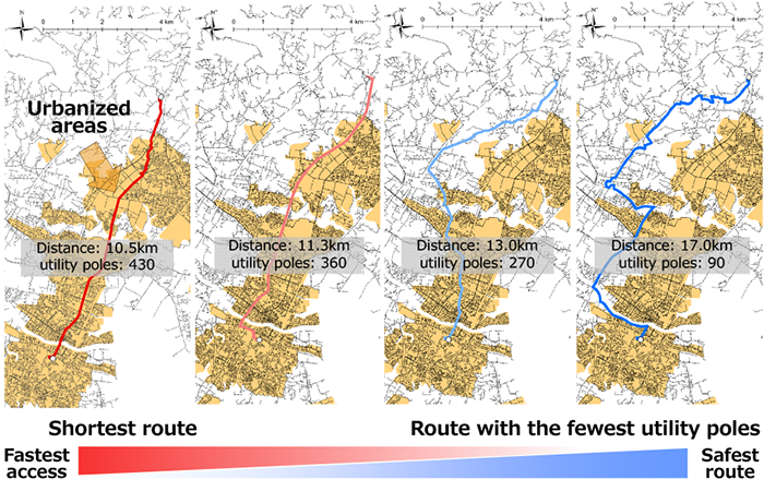
Figure 2: Identification of evacuation routes with fewer utility poles (the blue route with the fewest utility poles is the safest)
It is possible to identify candidate sites for pole-free zones by analyzing utility poles maps against building and population data. In Figure 2, the best evacuation route is the border between the urbanized areas with poles densely distributed, and the undeveloped urbanization control areas. For roads that may be blocked by fallen poles, and be difficult to access shelters in a disaster, we have to propose undergrounding planning, or present alternative routes. In Figure 2, we identified a “route with the fewest utility poles” as the best evacuation route when the shortest route to a shelter does not function. In similar methods, geospatial data are utilized to reduce risks associated with major disasters, including earthquakes and floods.
We also use big data for other original research, such as investigations on public transportation fares and studies to create comfortable running courses. We believe that being utilized by experts for policy-making and corporate strategies, the results of these analyses provide an important basis for social application.
Social contributions and achievements
- Safety research to identify risks associated with crimes and disasters
- Research to establish safe, efficient, and environmentally-friendly transportation systems
- Maintenance and renewal of deteriorating urban infrastructure facilities
- Research for intensive, compact, and network-type urban planning
- Presentation of methods and systems for decision-making using spatial data in society
Interviewed on February 14, 2020