キーワード: 地理情報科学、都市工学、空間解析、時空間データ
 カーナビ、スマホの普及に代表されるように、GPSによる 位置同定技術によって、誰もが即座に地図をみて、活用することができる時代になりました。このような「空間情報」は、都市計画、固定資産管理、ハザード マップに活用されることで行政を支援したり、出店計画やマーケティングなどに使われることで、民間企業の活動に利益をもたらしたりしています。
空間解析手法の戦略的な活用に挑戦する
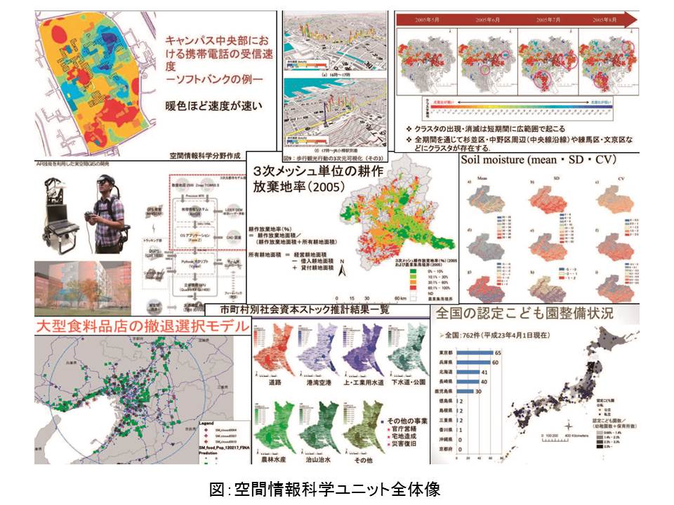
私たちが取り組んでいるのは、空間の有り様を追求する学問としての地理学と都市工学の2つの分野において進められている「空間情報」の解析技術の融合と、 それに基づいた戦略的な活用です。これらの分野では近年の情報化技術の進展によって方法論が著しく発展してきていますが、相乗効果を期待できる部分がある にもかかわらず、これまで相互交流は活発とはいえませんでした。この課題を解決するために地理学と都市工学の専門家が結集し、分野融合型・応用志向型の空 間解析手法の高度化と科学的知見の政策立案への戦略的活用に意欲的に取り組んでいるのが、空間情報科学リサーチユニットです(図)。
さまざまな空間情報から社会に役立つ情報を抽出する
「空間情報」は一般に巨大なデータです。膨大な量の情報から、我々の住む国土・都市・地域でどのような現象が起きているか、どのように都市を計画し、制御 していくべきか、を考える際には、適切な方法を用いて分析し、社会に役立つ情報に変換していく必要があります。私たちは現在、分野間の相互の適用可能性を 探りながら、(1)空間統計解析手法、(2)配置最適化・ネットワーク解析手法、(3)空間シミュレーション技術の3つに着目して研究しています。これら の研究を通じて、私たちの生活をより豊かにするような新たな時空間情報が生みだされつつあります。
社会への貢献・実績
●地理情報科学と都市工学で用いられる空間解析手法の体系的整理
●解析手法の長所・短所に関する経験的知見やノウハウの蓄積
●総合科学として実績のある地理学と、空間解析、都市・地域計画、リスク工学、立地分析など諸分野の空間解析手法の融合
●各専門領域における手法開発と分野を超えた展開の可能性
●空間解析手法の体系化と多様な分野間にまたがる新たな手法の相乗的発展
(取材:平成25年5月22日)
The Utilization of Spatiotemporal Information to Learn about Cities and Regions : Spatial Information Science
Unit members : Morimoto, Takehiro Sugita, Michiaki Tsutsumi, Morito Watanabe, Shun
Key words:geographical information science, urban engineering, spatial analysis, spatiotemporal data
As indicated by the widespread use of car navigation equipment and smartphones, this is an era that anyone can easily identify their actual location on a map and utilize this information by using GPS (global positioning system), technology providing precise data on position.
“Spatial information” is used for urban planning, fixed asset management, and hazard maps to improve administrative services. It is also used for the businesses of private companies such as plans for opening new stores and marketing.
Various academic applications of “spatial information” are also expected. The “Spatial Information Science” Research Unit aims to provide value-added spatial information on the basis of the geographical information system (GIS).
Strategic utilization of spatial analysis methods as a challenge
We are involved in the integration of techniques for “spatial information” analysis, which has been in progress in the fields of geography and urban engineering – two academic disciplines to examine the significance of space, and their strategic utilization based on integrated techniques. Despite notable progress in methodological approaches in these fields due to recent advancements in information technology, there has been no active interaction between the two fields, although synergistic effects have been expected. To address this problem, the spatial information science research unit, consisting of specialists in geography and urban engineering, has been actively promoting the sophistication of multidisciplinary/application-oriented spatial analysis methods and the strategic utilization of scientific knowledge for policy-making (Figure).
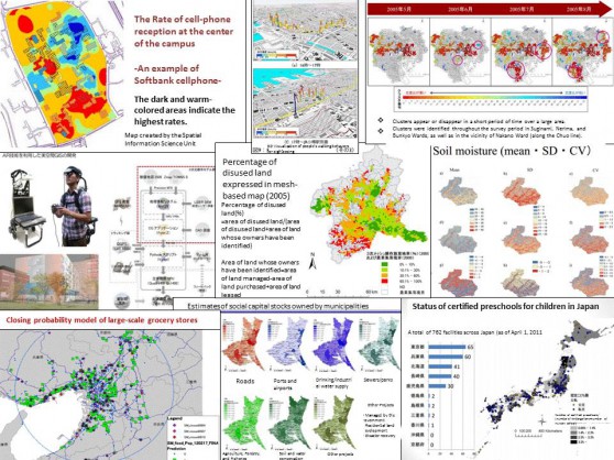
Figure: Overall picture of the Spatial Information Science Unit
Extraction of information from various spatial information sources
In general, “spatial information” comprises a large amount of data. It is necessary to analyze significant amounts of information using appropriate methods, and convert them into useful information for society, in order to examine various phenomena at the level of country, region and city, and to discuss urban planning and the control of cities.
We are conducting researches with emphasis on: (1) methods for spatial statistical analysis, (2) methods for optimization of allocation and network analysis, and (3) spatial simulation technology, while searching for mutual applicability across different scientific fields. We have provided new spatiotemporal information to improve our lives through these studies.
Social contributions and achievements
● Systematic organization of spatial analysis methods used in geographical information science and urban engineering
● Accumulation of empirical knowledge and know-how on the advantages and disadvantages of the analysis methods
● Integration of spatial analysis methods used in geography – an established general scientific discipline, and other fields, such as spatial analysis, city/regional community planning, risk engineering, and locational analysis.
● Development of methods in different specialized fields and the possibility of their advancement across the fields
● Systematic organization of spatial analysis methods and synergistic development of new methods across various fields